Anyone worried about Jimena?
Started by mel150 · Aug 30, 2009 · 69 replies
No I just talked to her and she is fine......really, she is my neighbor!
As far as the hurricane goes, I think it is moving west our further into sea. It will no doubt give us some waves and winds I am confident
As far as the hurricane goes, I think it is moving west our further into sea. It will no doubt give us some waves and winds I am confident
Wooo Hoooo another huricane party... I was here for Nora and we weathered the storm that time... lots of uprooted trees... not much structural damage one or two OK maybe a dozen of rooftops were blown off... we were lucky to be in a moon phase that didn't cause the massive tides we all know Penasco can get... high tides would have created much more damage then we received at the Malecon...
as Alfred E. Newman once said "What me worry?"
as Alfred E. Newman once said "What me worry?"
How is she going to affect the snorkeling for Labor Day weekend?
this what they are saying about Jimena:
"...JIMENA IS MOVING TOWARD THE NORTHWEST NEAR 9 MPH…15 KM/HR…AND A GRADUAL TURN TOWARD THE NORTH-NORTHWEST IS EXPECTED OVER THE NEXT COUPLE OF DAYS..."
So, it seems that might cause minor waves and winds, nothing that trikes with fat tires can not take, or stop a bunch of guys for having a fun time!!! IMHO
"...JIMENA IS MOVING TOWARD THE NORTHWEST NEAR 9 MPH…15 KM/HR…AND A GRADUAL TURN TOWARD THE NORTH-NORTHWEST IS EXPECTED OVER THE NEXT COUPLE OF DAYS..."
So, it seems that might cause minor waves and winds, nothing that trikes with fat tires can not take, or stop a bunch of guys for having a fun time!!! IMHO
Here's the projected track from Wunderground.com


Last edited: Aug 30, 2009 at 7:49 PM
Yea, I was there for Nora, too. We lost a 2 foot square section of the roll up blind that we used to staple to the sundeck poles to make a Mexico room that was up at the top right underneath the deck. It was the corner that wasn't protected by another trailer around us. We were lucky, being right on the beach in the Mirador. A few other trailers in Miramar were knocked off foundation, patios ripped off, arcadia doors blown in and one was destroyed by wind, water and a cave in. The storn was cool, tho.
I was also there for hurricane Eduardo in '76. I weathered that storm out in the Villa Granada, dancing. That was a good storm, too! I had to wait an extra day to drive home as all the washes were full by Why and the road was closed. My life in Mexico is never boring!
I was also there for hurricane Eduardo in '76. I weathered that storm out in the Villa Granada, dancing. That was a good storm, too! I had to wait an extra day to drive home as all the washes were full by Why and the road was closed. My life in Mexico is never boring!
Nora was cool we drove around and went to Las Conchas to see the roof blow off the old dive house... just glad we weren't in it then... it had big windows all around the pool and just about all of them were shattered and into the pool... last I heard the pool is now full of sand and it's a volleyball court now....
Here is a link...http://www.wrh.noaa.gov/psr/tropics/hurricanes.htm History of Hurricanes that impacted Arizona
Definitely going to mess with the weather. Big waves and more humidity. I was down last weekend. MIserable and alot of mosqitoes. As hot as I've ever seen it ,100 degrees at the beach and 113 in Sonoyta on Friday.Mountains for me until the summer heat is gone.
This morning's update....

And the computer models....a couple have it hitting right in the Penasco area.....by then it should have died down considerably....but the water will be churned up.
And the computer models....a couple have it hitting right in the Penasco area.....by then it should have died down considerably....but the water will be churned up.
Ladyjeeper said:Yea, I was there for Nora, too. We lost a 2 foot square section of the roll up blind that we used to staple to the sundeck poles to make a Mexico room that was up at the top right underneath the deck. It was the corner that wasn't protected by another trailer around us. We were lucky, being right on the beach in the Mirador. A few other trailers in Miramar were knocked off foundation, patios ripped off, arcadia doors blown in and one was destroyed by wind, water and a cave in. The storn was cool, tho.
I was also there for hurricane Eduardo in '76. I weathered that storm out in the Villa Granada, dancing. That was a good storm, too! I had to wait an extra day to drive home as all the washes were full by Why and the road was closed. My life in Mexico is never boring!
Did you see my postcard of the Villa Granada? It's an old one. That's where we stayed before our house was even started, much less finished in about 1974! Wonder if we have crossed paths?? The pics are on my main page....
see y'all for Thanksgiving - high country and tall pines for us on weekends in Az, and trips to SF and NOLA for some entertainment Sept-Oct.
life is great :)
life is great :)
I don't know, MYT. What main page, your facebook page? I'll PM ya when I get home from work and we can see if we know each other.
Ladyjeeper said:I don't know, MYT. What main page, your facebook page? I'll PM ya when I get home from work and we can see if we know each other.
No, the User CP page here on Rocky Point Talk.
What cool pics! Brings back the memories. Guess you know what I'll be doing tonight...looking for all my old pics and getting them together for scanning.
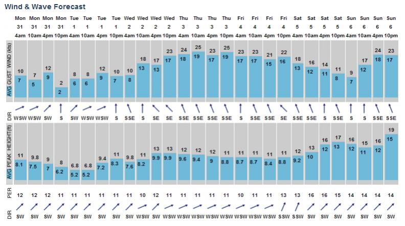
Well... I'm not worried because I'm not foolish enough to be out there (on the water). I've never seen a Buoyweather prediction quite like this, though. 8-11 ft. waves predicted all this week, with up to 12-19 ft. on Sunday!! This is predicted about 10 miles + out, although I'm sure it will still be plenty rough inshore.
Attachments
Last edited: Aug 31, 2009 at 11:43 AM
Stuart said:Well... I'm not worried because I'm not foolish enough to be out there (on the water). I've never seen a Buoyweather prediction quite like this, though. 8-11 ft. waves predicted all this week, with up to 12-19 ft. on Sunday!! This is predicted about 10 miles + out, although I'm sure it will still be plenty rough inshore.
Stuart it's not just dangerous being out on the water but the problem could be the high tides that will be in effect at the time...
during NORA we had low tides, a week later the tides were high and a freak wind came up and caused a lot of destruction on the Malecon... high tides and big waves could cause the slips in port to come off the pilons and this would be a serious problem for the boats in them...
back during NORA we sat on a 2 million dollar yacht with our knives in hand just incase waves got to big in port we were going out to sea... didn't happen so we just partied and enjoyed the storm...
Ladyjeeper said:What cool pics! Brings back the memories. Guess you know what I'll be doing tonight...looking for all my old pics and getting them together for scanning.
I don't know about you, LadyJ, but the Villa Granada was my first cerveza!
Oh, I could tell you stories! Drinking Grasshoppers and dancing......At 15. I'm sure we were in there at the same time. I'll dig up my old pics.
Memories........
Memories........
ladyjeeper said:oh, i could tell you stories! Drinking grasshoppers and dancing......at 15. I'm sure we were in there at the same time. I'll dig up my old pics.
Memories........
can't wait!!!
Stuart, you mind posting the link where you found that "Buoyweather" info?
Thanks!
Thanks!
Jimena Update
by DarkSyde
Mon Aug 31, 2009 at 03:40:04 PM PDT
Hurricane Jimena has undergone an impressive burst of intensification over the last 24 hours and is now essentially a Cat 5 storm with sustained winds of 155 mph. It is tracking toward the southern tip of the Baja peninsula and could make landfall as early as tomorrow evening. I'll be following the storm in detail with frequent NHC updates and temp/heat graphs here. For purposes of discussion we'll break it up into three scenarios:
Likely scenario -- the current forecast has Jimena making landfall as a major hurricane and tracking right over most of the Baja peninsula. That means hurricane force winds, torrential rain, massive storm surges along the coast, flash floods, and deadly mudslides. But the rugged Baja terrain should help throw a monkey wrench into the center of the storm.
Possible scenario -- Jimena stays mostly to the west of Baja and cuts up the Mexican-California coast. Sea surface temperatures drop off rapidly between Jimena's present position toward the west coast and San Diego. Odds are Jimena would weaken a great deal if it follows that path and become a tropical storm or relatively weak hurricane.
Worst case scenario -- it is within the realm of possibility that Jimena drifts east quicker than expected and into the narrow, warm Sea of Cortez where it either intensifies or remains a major hurricane, threading the watery needle all the way to landfall south of the California-Arizona border.
To sum it up: residents of southern and central Baja should either evac -- especially in low laying coastal regions or passes -- or be prepared to ride out a major, life threatening hurricane beginning tomorrow complete with loss of power, water, and emergency services lasting days or weeks. Residents along the lower west US coast and southern CA-AZ border, particularly those near sea level, gulches, and other flood prone areas should bookmark and follow the National Hurricane Center, the Weather Underground, and be prepared to quickly move to higher, stable ground and/or seek storm rated shelters.
by DarkSyde
Mon Aug 31, 2009 at 03:40:04 PM PDT
Hurricane Jimena has undergone an impressive burst of intensification over the last 24 hours and is now essentially a Cat 5 storm with sustained winds of 155 mph. It is tracking toward the southern tip of the Baja peninsula and could make landfall as early as tomorrow evening. I'll be following the storm in detail with frequent NHC updates and temp/heat graphs here. For purposes of discussion we'll break it up into three scenarios:
Likely scenario -- the current forecast has Jimena making landfall as a major hurricane and tracking right over most of the Baja peninsula. That means hurricane force winds, torrential rain, massive storm surges along the coast, flash floods, and deadly mudslides. But the rugged Baja terrain should help throw a monkey wrench into the center of the storm.
Possible scenario -- Jimena stays mostly to the west of Baja and cuts up the Mexican-California coast. Sea surface temperatures drop off rapidly between Jimena's present position toward the west coast and San Diego. Odds are Jimena would weaken a great deal if it follows that path and become a tropical storm or relatively weak hurricane.
Worst case scenario -- it is within the realm of possibility that Jimena drifts east quicker than expected and into the narrow, warm Sea of Cortez where it either intensifies or remains a major hurricane, threading the watery needle all the way to landfall south of the California-Arizona border.
To sum it up: residents of southern and central Baja should either evac -- especially in low laying coastal regions or passes -- or be prepared to ride out a major, life threatening hurricane beginning tomorrow complete with loss of power, water, and emergency services lasting days or weeks. Residents along the lower west US coast and southern CA-AZ border, particularly those near sea level, gulches, and other flood prone areas should bookmark and follow the National Hurricane Center, the Weather Underground, and be prepared to quickly move to higher, stable ground and/or seek storm rated shelters.
Jerry-- DarkSyde? The great orange satan??? I'm shocked, SHOCKED, I tell you! ;)
I didn't start hanging out at the Villa 'til the late 80's but my wife Josefina was a waitress/bartender 30+ years ago. I sure miss Jonathen and all the good times at the Villa.
www.buoyweather.com It will only give you a 2 day forecast without a membership
It's a small world, indeed. I'm sure a lot of us would recognize each other by sight.
That should be a doozy if Jimena crosses Baja and continues up the Sea of Cortez....especially with a new moon ( I think it's Friday)....an interesting sea surge!!!
Ladyjeeper said:It's a small world, indeed. I'm sure a lot of us would recognize each other by sight.
you might see my photo in the post office... (just Joking)
rockyptjoe said:That should be a doozy if Jimena crosses Baja and continues up the Sea of Cortez....especially with a new moon ( I think it's Friday)....an interesting sea surge!!!
High tide is at 2:20 pm on saturday and one of the prediction models I saw show the storm hitting at 2:00 pm... interesting to say the least...
Last edited: Sep 1, 2009 at 1:16 AM
Hurricane JIMENA Public Advisory
Home Public Adv Fcst/Adv Discussion Wind Probs Maps/Charts Archive
000
WTPZ33 KNHC 011152
TCPEP3
BULLETIN
HURRICANE JIMENA INTERMEDIATE ADVISORY NUMBER 15A
NWS TPC/NATIONAL HURRICANE CENTER MIAMI FL EP132009
500 AM PDT TUE SEP 01 2009
...EXTREMELY DANGEROUS HURRICANE JIMENA HEADING TOWARD THE BAJA
PENINSULA...
A HURRICANE WARNING IS IN EFFECT FOR THE SOUTHERN PORTION OF THE
BAJA CALIFORNIA PENINSULA FROM PUERTO SAN ANDRESITO SOUTHWARD ON
THE WEST COAST...AND FROM LORETO SOUTHWARD ON THE EAST COAST...
INCLUDING CABO SAN LUCAS. A HURRICANE WARNING MEANS THAT HURRICANE
CONDITIONS ARE EXPECTED SOMEWHERE WITHIN THE WARNING AREA WITHIN 24
HOURS. CONDITIONS ARE EXPECTED TO DETERIORATE OVER THE SOUTHERN
PORTION OF THE WARNING AREA LATER TODAY AND PREPARATIONS
TO PROTECT LIFE AND PROPERTY SHOULD BE RUSHED TO COMPLETION.
A HURRICANE WATCH IS IN EFFECT FOR THE BAJA CALIFORNIA PENINSULA
NORTH OF PUERTO SAN ANDRESITO ON THE WEST COAST TO PUNTA
EUGENIA...AND NORTH OF LORETO ON THE EAST COAST TO BAHIA SAN
JUAN BAUTISTA. A HURRICANE WATCH MEANS THAT HURRICANE CONDITIONS
ARE POSSIBLE WITHIN THE WATCH AREA...GENERALLY WITHIN 36 HOURS.
A TROPICAL STORM WATCH IS IN EFFECT FOR THE WEST COAST OF MAINLAND
MEXICO FROM ALTATA TO HUATABAMPITO. A TROPICAL STORM WATCH MEANS
THAT TROPICAL STORM CONDITIONS ARE POSSIBLE WITHIN THE WATCH
AREA...GENERALLY WITHIN 36 HOURS. THIS WATCH MAY BE EXTENDED
NORTHWARD LATER TODAY.
INTERESTS ELSEWHERE IN THE BAJA CALIFORNIA PENINSULA AND IN
WESTERN MAINLAND MEXICO SHOULD MONITOR THE PROGRESS OF JIMENA.
FOR STORM INFORMATION SPECIFIC TO YOUR AREA...PLEASE MONITOR
PRODUCTS ISSUED BY YOUR NATIONAL METEOROLOGICAL SERVICE.
AT 500 AM PDT...1200 UTC...THE CENTER OF HURRICANE JIMENA WAS
LOCATED NEAR LATITUDE 20.6 NORTH...LONGITUDE 110.4 WEST OR ABOUT
155 MILES...250 KM...SOUTH OF CABO SAN LUCAS MEXICO AND ABOUT
315 MILES...505 KM...SOUTH-SOUTHEAST OF CABO SAN LAZARO MEXICO.
JIMENA IS MOVING TOWARD THE NORTH-NORTHWEST NEAR 12 MPH...
19 KM/HR...AND THIS GENERAL MOTION IS EXPECTED TO CONTINUE DURING
THE NEXT DAY OR TWO. ON THE FORECAST TRACK...JIMENA WILL BE
APPROACHING THE SOUTHERN PORTION OF THE BAJA CALIFORNIA PENINSULA
LATER TODAY AND TONIGHT.
MAXIMUM SUSTAINED WINDS ARE NEAR 155 MPH...250 KM/HR...WITH HIGHER
GUSTS. JIMENA IS A CATEGORY FOUR HURRICANE ON THE SAFFIR-SIMPSON
SCALE...AND VERY NEAR THE THRESHOLD OF CATEGORY FIVE STATUS. SOME
FLUCTUATIONS IN STRENGTH ARE LIKELY TODAY...AND GRADUAL WEAKENING
IS FORECAST ON WEDNESDAY. HOWEVER...JIMENA IS EXPECTED TO REMAIN
A MAJOR HURRICANE UNTIL LANDFALL.
HURRICANE FORCE WINDS EXTEND OUTWARD UP TO 45 MILES...75 KM...FROM
THE CENTER...AND TROPICAL STORM FORCE WINDS EXTEND OUTWARD UP TO
140 MILES...220 KM.
ESTIMATED MINIMUM CENTRAL PRESSURE IS 931 MB...27.49 INCHES.
JIMENA IS EXPECTED TO PRODUCE TOTAL RAIN ACCUMULATIONS OF 5 TO 10
INCHES OVER THE SOUTHERN HALF OF THE BAJA CALIFORNIA PENINSULA AND
PORTIONS OF WESTERN MEXICO DURING THE NEXT COUPLE OF DAYS...WITH
POSSIBLE ISOLATED MAXIMUM AMOUNTS OF 15 INCHES.
A DANGEROUS STORM SURGE ALONG WITH BATTERING WAVES WILL PRODUCE
SIGNIFICANT COASTAL FLOODING ALONG THE BAJA CALIFORNIA PENINSULA.
...SUMMARY OF 500 AM PDT INFORMATION...
LOCATION...20.6N 110.4W
MAXIMUM SUSTAINED WINDS...155 MPH
PRESENT MOVEMENT...NORTH-NORTHWEST OR 330 DEGREES AT 12 MPH
MINIMUM CENTRAL PRESSURE...931 MB
THE NEXT ADVISORY WILL BE ISSUED BY THE NATIONAL HURRICANE CENTER AT
800 AM PDT.
$$
FORECASTER BROWN/BEVEN
Home Public Adv Fcst/Adv Discussion Wind Probs Maps/Charts Archive
000
WTPZ33 KNHC 011152
TCPEP3
BULLETIN
HURRICANE JIMENA INTERMEDIATE ADVISORY NUMBER 15A
NWS TPC/NATIONAL HURRICANE CENTER MIAMI FL EP132009
500 AM PDT TUE SEP 01 2009
...EXTREMELY DANGEROUS HURRICANE JIMENA HEADING TOWARD THE BAJA
PENINSULA...
A HURRICANE WARNING IS IN EFFECT FOR THE SOUTHERN PORTION OF THE
BAJA CALIFORNIA PENINSULA FROM PUERTO SAN ANDRESITO SOUTHWARD ON
THE WEST COAST...AND FROM LORETO SOUTHWARD ON THE EAST COAST...
INCLUDING CABO SAN LUCAS. A HURRICANE WARNING MEANS THAT HURRICANE
CONDITIONS ARE EXPECTED SOMEWHERE WITHIN THE WARNING AREA WITHIN 24
HOURS. CONDITIONS ARE EXPECTED TO DETERIORATE OVER THE SOUTHERN
PORTION OF THE WARNING AREA LATER TODAY AND PREPARATIONS
TO PROTECT LIFE AND PROPERTY SHOULD BE RUSHED TO COMPLETION.
A HURRICANE WATCH IS IN EFFECT FOR THE BAJA CALIFORNIA PENINSULA
NORTH OF PUERTO SAN ANDRESITO ON THE WEST COAST TO PUNTA
EUGENIA...AND NORTH OF LORETO ON THE EAST COAST TO BAHIA SAN
JUAN BAUTISTA. A HURRICANE WATCH MEANS THAT HURRICANE CONDITIONS
ARE POSSIBLE WITHIN THE WATCH AREA...GENERALLY WITHIN 36 HOURS.
A TROPICAL STORM WATCH IS IN EFFECT FOR THE WEST COAST OF MAINLAND
MEXICO FROM ALTATA TO HUATABAMPITO. A TROPICAL STORM WATCH MEANS
THAT TROPICAL STORM CONDITIONS ARE POSSIBLE WITHIN THE WATCH
AREA...GENERALLY WITHIN 36 HOURS. THIS WATCH MAY BE EXTENDED
NORTHWARD LATER TODAY.
INTERESTS ELSEWHERE IN THE BAJA CALIFORNIA PENINSULA AND IN
WESTERN MAINLAND MEXICO SHOULD MONITOR THE PROGRESS OF JIMENA.
FOR STORM INFORMATION SPECIFIC TO YOUR AREA...PLEASE MONITOR
PRODUCTS ISSUED BY YOUR NATIONAL METEOROLOGICAL SERVICE.
AT 500 AM PDT...1200 UTC...THE CENTER OF HURRICANE JIMENA WAS
LOCATED NEAR LATITUDE 20.6 NORTH...LONGITUDE 110.4 WEST OR ABOUT
155 MILES...250 KM...SOUTH OF CABO SAN LUCAS MEXICO AND ABOUT
315 MILES...505 KM...SOUTH-SOUTHEAST OF CABO SAN LAZARO MEXICO.
JIMENA IS MOVING TOWARD THE NORTH-NORTHWEST NEAR 12 MPH...
19 KM/HR...AND THIS GENERAL MOTION IS EXPECTED TO CONTINUE DURING
THE NEXT DAY OR TWO. ON THE FORECAST TRACK...JIMENA WILL BE
APPROACHING THE SOUTHERN PORTION OF THE BAJA CALIFORNIA PENINSULA
LATER TODAY AND TONIGHT.
MAXIMUM SUSTAINED WINDS ARE NEAR 155 MPH...250 KM/HR...WITH HIGHER
GUSTS. JIMENA IS A CATEGORY FOUR HURRICANE ON THE SAFFIR-SIMPSON
SCALE...AND VERY NEAR THE THRESHOLD OF CATEGORY FIVE STATUS. SOME
FLUCTUATIONS IN STRENGTH ARE LIKELY TODAY...AND GRADUAL WEAKENING
IS FORECAST ON WEDNESDAY. HOWEVER...JIMENA IS EXPECTED TO REMAIN
A MAJOR HURRICANE UNTIL LANDFALL.
HURRICANE FORCE WINDS EXTEND OUTWARD UP TO 45 MILES...75 KM...FROM
THE CENTER...AND TROPICAL STORM FORCE WINDS EXTEND OUTWARD UP TO
140 MILES...220 KM.
ESTIMATED MINIMUM CENTRAL PRESSURE IS 931 MB...27.49 INCHES.
JIMENA IS EXPECTED TO PRODUCE TOTAL RAIN ACCUMULATIONS OF 5 TO 10
INCHES OVER THE SOUTHERN HALF OF THE BAJA CALIFORNIA PENINSULA AND
PORTIONS OF WESTERN MEXICO DURING THE NEXT COUPLE OF DAYS...WITH
POSSIBLE ISOLATED MAXIMUM AMOUNTS OF 15 INCHES.
A DANGEROUS STORM SURGE ALONG WITH BATTERING WAVES WILL PRODUCE
SIGNIFICANT COASTAL FLOODING ALONG THE BAJA CALIFORNIA PENINSULA.
...SUMMARY OF 500 AM PDT INFORMATION...
LOCATION...20.6N 110.4W
MAXIMUM SUSTAINED WINDS...155 MPH
PRESENT MOVEMENT...NORTH-NORTHWEST OR 330 DEGREES AT 12 MPH
MINIMUM CENTRAL PRESSURE...931 MB
THE NEXT ADVISORY WILL BE ISSUED BY THE NATIONAL HURRICANE CENTER AT
800 AM PDT.
$$
FORECASTER BROWN/BEVEN
MT..I'm a "visual" type person....
Computer forecasts....
Computer forecasts....
Web cam view from Pices Sportfishing in Cabo (which may be missed)
http://pisces.linksysremoteview.com/img/main.cgi?next_file=main.htm
http://pisces.linksysremoteview.com/img/main.cgi?next_file=main.htm
So, does anyone know what the forecast is for RP itself? Don't know if we should just stay home or go ahead and go.
rockyptjoe said:MT..I'm a "visual" type person....
Computer forecasts....
Yours is definitely more entertaining and easy to look at...
MT....I love the variety in the projected tracks!!! I guess until it hits land somewhere(like Baja), it is very difficult to predict.
http://www.tripadvisor.com/ShowTopic-g152515-i84-k3060190-Keep_an_eye_on_Jimena-Cabo_San_Lucas_Los_Cabos_Baja_California.html
I've been following that link above, quite a few locals in Cabo are posting updates and pics. The resorts are getting hit with heavy rains as we speak.
I've been following that link above, quite a few locals in Cabo are posting updates and pics. The resorts are getting hit with heavy rains as we speak.
I plan on leaving Tucson friday morning and riding out the storm at our house in Las Conchas. Any thoughts on the power grid? How has it weathered in the past during big storms and how quickly do you think they can repair downed lines?
Maybe later today the forecast will include RP. Right now Jimena can't decide if she wants to be a Cat 4 or 5. :-o :eek:
cheatka said:So, does anyone know what the forecast is for RP itself? Don't know if we should just stay home or go ahead and go.
Key lines from latest discussion on weather.com
Impacts from Jimena will be felt along mainland Mexico as well. Dangerous rip currents, large and battering waves and heavy, flooding rainfall are expected.
The waves and rip currents are occurring from Manzanillo northward, while the heaviest rain should fall from Mazatlan north.
As we get closer to Friday, expect more mentions of our coast further up north. Just too unpredictable now, especially since Jimena is currently going through an eyewall replacement cycle.
Impacts from Jimena will be felt along mainland Mexico as well. Dangerous rip currents, large and battering waves and heavy, flooding rainfall are expected.
The waves and rip currents are occurring from Manzanillo northward, while the heaviest rain should fall from Mazatlan north.
As we get closer to Friday, expect more mentions of our coast further up north. Just too unpredictable now, especially since Jimena is currently going through an eyewall replacement cycle.
If it comes, pray for low tide like Nora!
I guess this guy is pretty famous for getting hurricane videos. Just look at the name of his site: http://extremestorms.com/
Just some photos and updates posted so far, though.
Just some photos and updates posted so far, though.
Dezracer said:I plan on leaving Tucson friday morning and riding out the storm at our house in Las Conchas. Any thoughts on the power grid? How has it weathered in the past during big storms and how quickly do you think they can repair downed lines?
during NORA they shut the power down before it hit to try to minimalize any problems from downed powerlines... and as I recall the power wasn't down for vey long...
http://www.surfline.com/surf-report/monuments-southern-baja_6115
If you've ever surfed or boogieboarded etc. in cabo you can picture this,,,,31-42 ft. waves
If you've ever surfed or boogieboarded etc. in cabo you can picture this,,,,31-42 ft. waves
no sweat, I'm on my
Hamilton say's no sweat, I'm on my way.http://www.youtube.com/watch?v=s0Pw7vKtqpo
jerry said:http://www.surfline.com/surf-report/monuments-southern-baja_6115
If you've ever surfed or boogieboarded etc. in cabo you can picture this,,,,31-42 ft. waves
Hamilton say's no sweat, I'm on my way.http://www.youtube.com/watch?v=s0Pw7vKtqpo
Holy Crap!! That is Awesome Kenny!!
Looks like Jimena can't make up her mind....just like a female!!! Oh...I may get slapped around a bit...
The 5pm(ET) Forecast Models
The 5pm(ET) Forecast Models
I'm going to be pissed if she makes me go all the way down there and then she doesn't wreck my house!
Send pics..........
Weather.com shows winds 8-11 mph and temps 88-95 Farenheit from Thursday through Tuesday! As my friend Valerie would say, "That's not enough to make the sand stick to your lipstick!" Unless something else changes that forecast we will not change our plans to be there.
That does not include what Jimena could do come Saturday. Just keep checking here as a lot of people are watching it for everyone....
LOL, Kandy! I was talking to Valerie as I read the post. I'll see you Friday night.
Chuck, at what time are you guys leaving on Friday/
Inka,
I'll pick Valerie up from school around 3:30. So we'll be in just after it's gets dark. I'm bringing a staircase down for my patio. The thing takes up almost my whole truck bed. I hope I don't get the red light. My Mom will be at PDO.
I'll pick Valerie up from school around 3:30. So we'll be in just after it's gets dark. I'm bringing a staircase down for my patio. The thing takes up almost my whole truck bed. I hope I don't get the red light. My Mom will be at PDO.
Warnings are getting closer....
"A tropical storm watch is in effect for the West Coast of Mainland
Mexico from Altata to Bahia Kino."
http://www.wunderground.com/tropical/ep200913.public.html#a_topad
"A tropical storm watch is in effect for the West Coast of Mainland
Mexico from Altata to Bahia Kino."
http://www.wunderground.com/tropical/ep200913.public.html#a_topad
GringoZona said:Warnings are getting closer....
"A tropical storm watch is in effect for the West Coast of Mainland
Mexico from Altata to Bahia Kino."
http://www.wunderground.com/tropical/ep200913.public.html#a_topad
it's getting pretty cloudy right now but that's all, no winds or rain...
Last edited: Sep 2, 2009 at 8:09 AM
Another beautiful weekend is unfolding in paradise, sigh!!!
Well, it looks like Jimena may be "finished"....latest 5 day projections....
The computer models.....
The computer models.....
I am loving this weather its a nice change
How are things looking, weatherwise, for the weekend? San Carlos got hit hard overnight, the convection layer all blew over the mainland with tropical storm warnings up to Puerto Libertad (last I checked), and monsoonal weather is expected in Arizona starting Friday, with rain, thunder and lightning. The actual storm stayed over Baja, which is in very bad shape especially from Santa Rosalia south past Mulege (Mulege is totally cut off, Loreto is expected to be without power for 6 days-- they could use a little love...).
I'm getting emails from folks who are worried about driving down for the weekend due to possible flooding.
What are you hearing?
I'm getting emails from folks who are worried about driving down for the weekend due to possible flooding.
What are you hearing?

Here's what I gather about those affected from the articles translated:
Yesterday
"La Paz-Ciudad Constitucion, San Carlos, just over 50 thousand people around the towns without light and water." (who had it before).
"The parastatal explained that the strong wind knocked over a 1200 posts, 102 towers and damaged the circuits of distribution and transmission lines."
Today
http://www.eluniversal.com.mx/estados/72975.html
"Jimena" leaves to 75 thousand without services in BCS
"The Federal Electricity Commission (CFE) reported that 59 thousand people in Loreto, Ciudad Constitucion, Santa Rosalia, Puerto San Carlos, Mulege, Comondú Villa Insurgentes and other villages were left without light."
"In the municipalities of Comondu and Mulege at least 2 thousand homes have been severely damaged. In the town of Puerto Adolfo López Mateos some 250 are recorded damage in Mulege over 600, including 300 with total damage."
"The delegate Ivan de la Toba reported that Lopez Mateos-... are without the services of electricity or running water, and that the 500 evacuees exceeded the capacity of shelters, which is 300."
---------
http://www.oem.com.mx/elsudcaliforniano/notas/n1309603.htm
"Travel is limited to 4x4 and is difficult to pass from La Paz to Constituccion due to obstacles, mud, and road problems."
In Mulege County 6,000 people require temporary (albergadas) housing.
In Cabo region 3500
In La Paz region 1500
In Loreto region 417
Most other regions not yet reporting
---------
http://www.oem.com.mx/elsudcaliforniano/notas/n1311817.htm
"On his way through Baja California, Hurricane Jimena "devastated Magdalena Island, about 200 homes were destroyed, leaving hundreds of homeless people, who for two centuries are settled in this majestic stretch of land, about 200 families are in distress and urgent clamor for government intervention at all three levels, said Martin de la Toba Miranda."
----------
http://noticias.prodigy.msn.com/Fotogalerias/huracan_jimena.aspx?cp-documentid=21453387
----------
http://www.jornada.unam.mx/2009/09/04/index.php?section=estados&article=035n1est
In Mulege 8,000 people are in temporary shelter
Sonora declares emergency in 12 municipalities
----------
In Mulege one death was reported. Rafael Cuesta Real 69 years old pased away.
Authorities reported that a septuagenarian Mulege, identified as Rafael Cuesta, drowned in their homes. And in the fishing village of San Buto, Comondú municipality, a person remains missing.
--------
Yesterday
"La Paz-Ciudad Constitucion, San Carlos, just over 50 thousand people around the towns without light and water." (who had it before).
"The parastatal explained that the strong wind knocked over a 1200 posts, 102 towers and damaged the circuits of distribution and transmission lines."
Today
http://www.eluniversal.com.mx/estados/72975.html
"Jimena" leaves to 75 thousand without services in BCS
"The Federal Electricity Commission (CFE) reported that 59 thousand people in Loreto, Ciudad Constitucion, Santa Rosalia, Puerto San Carlos, Mulege, Comondú Villa Insurgentes and other villages were left without light."
"In the municipalities of Comondu and Mulege at least 2 thousand homes have been severely damaged. In the town of Puerto Adolfo López Mateos some 250 are recorded damage in Mulege over 600, including 300 with total damage."
"The delegate Ivan de la Toba reported that Lopez Mateos-... are without the services of electricity or running water, and that the 500 evacuees exceeded the capacity of shelters, which is 300."
---------
http://www.oem.com.mx/elsudcaliforniano/notas/n1309603.htm
"Travel is limited to 4x4 and is difficult to pass from La Paz to Constituccion due to obstacles, mud, and road problems."
In Mulege County 6,000 people require temporary (albergadas) housing.
In Cabo region 3500
In La Paz region 1500
In Loreto region 417
Most other regions not yet reporting
---------
http://www.oem.com.mx/elsudcaliforniano/notas/n1311817.htm
"On his way through Baja California, Hurricane Jimena "devastated Magdalena Island, about 200 homes were destroyed, leaving hundreds of homeless people, who for two centuries are settled in this majestic stretch of land, about 200 families are in distress and urgent clamor for government intervention at all three levels, said Martin de la Toba Miranda."
----------
http://noticias.prodigy.msn.com/Fotogalerias/huracan_jimena.aspx?cp-documentid=21453387
----------
http://www.jornada.unam.mx/2009/09/04/index.php?section=estados&article=035n1est
In Mulege 8,000 people are in temporary shelter
Sonora declares emergency in 12 municipalities
----------
In Mulege one death was reported. Rafael Cuesta Real 69 years old pased away.
Authorities reported that a septuagenarian Mulege, identified as Rafael Cuesta, drowned in their homes. And in the fishing village of San Buto, Comondú municipality, a person remains missing.
--------
Thanks for that, Jerry.
JimMcG said:Thanks for that, Jerry.
I'm thinking I should just go down Jim. This could be a once in a lifetime deal.
http://picasaweb.google.com/cybercoseguridad
pictures a guy took in San Carlos.... man we all dodged a bullet!!!!!!!
pictures a guy took in San Carlos.... man we all dodged a bullet!!!!!!!
Thanks for the info Jerry, even though you obviously selected it to support Obama and taint GW. Commie Pinko Ratfink.
fascist
Where ya been, you fascist pig.:mrgreen:
Roberto said:Thanks for the info Jerry, even though you obviously selected it to support Obama and taint GW. Commie Pinko Ratfink.
Where ya been, you fascist pig.:mrgreen:
I'll been a little preoccupied. I'll tell you about the sisters from Chiapas privately.