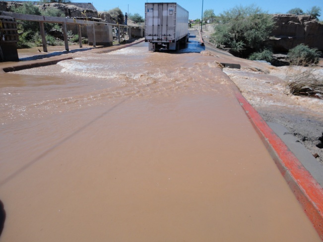
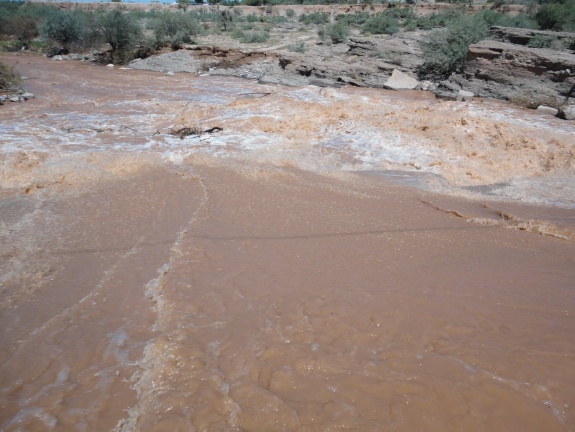
Sonoyta Safety Department - somewhat of an oxymoron
I was thinking the same thing! Despite their declaration, on the Senoyta Detours Update FB page, there are reports of semi trucks being allowed to cross, as well as a woman who says she just got through in an SUV. The info is so conflicting, it's hard to know what's actually going on.
He was coming down Jack and he decided not to wait and turned around and went back home. He was still wondering when he called me if he'd done the right thing, and after reading all these conflicting reports, who in the hell knows.LOL
He was coming down Jack and he decided not to wait and turned around and went back home. He was still wondering when he called me if he'd done the right thing, and after reading all these conflicting reports, who in the hell knows.LOL
That surprises me because he usually comes through Nogales to get there. He usually goes back through Lukeville.
Wonderful. Oh, but now there's an end-of-the-world-looking storm coming into Penasco. So will hunker down for now, and hope for continued access tomorrow.
I was just perusing the forum to see what's new before I head down next week to Tomas. I see this thread I started last May has had a long and active life. The Facebook page has a great photo of Rio Sonoyta flowing wide and muddy. Last posts there said everything is open as of today. I guess I have been MIA again. Bummer about Jerry getting banned. I hope he can be rehabilitated someday.
Bummer about Jerry getting banned. I hope he can be rehabilitated someday.
We all do.
He's got 16 days to go, but will probably get a few days off his sentence for good behavior while in Banned Camp and helping all those Boy Scouts earn their merit badges in whittling.
Meanwhile back to the detour deal. Does anyone know where that wash, creek, river originates?
I would think one could predict the crossability by watching the radar rainfall upstream and get a
pretty good snapshot of what will be going on there in the next few hours or even days.
For example, the only rain anywhere near Sonoyta is over in the Yuma area and it's been raining
for a few days over there. There is nothing north to speak of but a bunch around Green Valley and
Tucson right now. There is quite a bit of rain around Nogales and a few showers around Lobos.
If it's coming from the west, then I suspect that water will be running for quite a while yet.
All conjecture but something to think about on a boring no golf Monday.
PS: Surfer...you might want to check the culprit's record, if admissable. Not his first offense.:jerry:
Does anyone know if the bridge on the Mexican highway (Hwy 2) between San Luis and Sonoyta has re-opened?
I recall seeing some photos of it partially collapsed back about 3 weeks ago, and that was why all the trucks were going by way of the coast highway through Penasco.
Does anyone know if the bridge on the Mexican highway (Hwy 2) between San Luis and Sonoyta has re-opened?
I recall seeing some photos of it partially collapsed back about 3 weeks ago, and that was why all the trucks were going by way of the coast highway through Penasco.
Spoke with some folks who drove from Sonoyta to San Luis a few days ago and they did not see a damaged bridge or a detour. I asked directly about that. So apparently it is not a problem.
Here's a capture showing the drainage just across the border north and east of Sonoita. Look at all the little fingers collecting and delivering to the river right there. I would guess that if a storm passes over that area it would contribute most of the flow at Sonoita and almost immediately too. Water further upstream may not even reach Sonoita.
Well sorry but that capture did not work well but if you look on a Google map that water shed is very clear.
Good call Roberto...It is called the San Simon Watershed. I hope it works out where you can see it.
It runs north to south east of Why, and through to Mexico. It has a bunch of washes spilling into it. It appears to join the Rio Sonoyta to the east of town.
So my guess is that by watching the rain to the east and north of Sonoyta you will get an idea of the future situation in town.
The good news is that hopefully this mid-week things will dry out. I sure hope so cause I'm coming down a week from Wednesday.. FAIR Warning
I went up to Lukeville and back today. Got there about 2:00 and crossed a little more than a foot of water on the bridge. By the time I finished with the Post Office etc the road barely had any water over top on the way back. Glad that I went when I did because it looks pretty bad in that direction again tonight.
From Rocky Point Press Release FB page. 9/11 12:05 PM
Last night the border bridge was available just for big trucks, but since the receint rains this early morning, it is inaccessible. We also must let you know that the Puerto Penasco-Sonoyta highway it dangerous since the road is too wet. Please drive carefully and respect all signs on your way. We recomend to take the Golfo de Santa Clara Highway in both directions
Drove over the bridge last nite around 7pm. There was no water running over and lite traffic. All types and sizes of vehicles were crossing. I waited about 5 minutes to get thru alternating traffic. The road from sonoyta to san luis is a mess, I drove that on Saturday morning. No traffic on the road, not well marked and a challenge in the day lite. Lots of diversions off the main road A much tougher and dangerous ride at nite I am sure. It took me about 2.5 hours to drive the road to where turnoff is to El Golfo then to Penasco. Total detour was 4.5 hours
We didnt risk it today drove to Yuma and then to Phx 8 hours which included the wait at the inspection station outside El Golfo and 1hour to cross San Luis but a beautiful stress free drive with my wife of 30 years!
Good News, Sonoyta Detour Updates reports the following.
Sept 12 9:25 a.m. News from resident next to bridge in Sonoyta: "I live next the detour before the bridge and the police man just told me that all vehicles are permitted. 9:25"
Hopefully these storms are gone for awhile and we can get back to normal, whatever that is. Please hold on until next Wednesday after that let it rain and I'll just have to stay down there.
Sept 12 11:20 a.m. Report from traveler in Hyundai Santa Fe: Road is open, wait heading North was about 20 minutes. One lane open, swift water but some smaller cars and sedans going through
we got in line Friday about 5:00 PM right at the corner of the Circle K/Pemex. No movement so walked to the bridge and only northboud was allowed. The water was rushing and I saw it move several vehicles inlcuding one of the guys ferrying cars on a flatbed trailer. I think it was really too much water at that time. One guy in a small truck was moved sideways about 4 feet, but he did make it...barely. Decided it would be at least 3 hours so went back to Phx. Any updates this morning? I am heading back down.
Sept 15 8 a.m. Per Sonoyta Police Dept. the road remains CLOSED, while water is going down they do not expect to open until at least 10 a.m. and say expect LOOOOONG lines
Had friends in it last night and it was terrible. Lots of people with reservations and could not get thru. Some flew in from other states as well. Not a good weekend for rp. I read that someone had phoned in to tv news about it but no one heard anything. Will probally be on the news today but now it will be in a negative form. I hope they get this new bridge done soon...especially with fall break coming up.
I wonder why they didnt release water during night when
border is closed. Also could of prepared for it by sand bagging...cause there is plenty of that.
Terry C just posted on the Sonoyta Detour site that it is open now.
I tried to find a dam on the wash and the river and can't find anything. I did see there is a
resevoir up in AZ on one wash, but can't tie it in. I guess the road from Caborca in is having
flooding problems also. I sure hope this mess clears up by Wednesday.
Terry C just posted on the Sonoyta Detour site that it is open now.
I tried to find a dam on the wash and the river and can't find anything. I did see there is a
resevoir up in AZ on one wash, but can't tie it in. I guess the road from Caborca in is having
flooding problems also. I sure hope this mess clears up by Wednesday.
Very true Jack, Caborca road is bad at night, a singer from a band lost his life there this week when he hit a wash close to Penasco, three other where taken to hospital.
I was looking at google maps and it seems that the picture was taken before the bridge was torn down but you can see the water is coming towards Sonoyta right about where the farm land ends and the town starts, if you look at the river bed at Sonoyta it is dry and as you go east following the river it gets wet from them on to the point where it goes north to AZ and south where it gets dry again, however there is no reservoir or any area where some type of reservoir exist.
If, as the police says, some one built one he must have spent the last 10 years to build for the amount of water it is releasing!
I was looking at google maps and it seems that the picture was taken before the bridge was torn down but you can see the water is coming towards Sonoyta right about where the farm land ends and the town starts, if you look at the river bed at Sonoyta it is dry and as you go east following the river it gets wet from them on to the point where it goes north to AZ and south where it gets dry again, however there is no reservoir or any area where some type of reservoir exist.
If, as the police says, some one built one he must have spent the last 10 years to build for the amount of water it is releasing!
Inka...I totally agree with you. I did the same thing with Google Maps and looked all over the area and found nothing to resemble a big lake or resevoir.
I think the amount of water that has come through would have drained Patagonia Lake by now...so what gives? We know it's not rain so where can it be coming from?
a couple of weeks ago someone in Sonoyta told me that there is a reservoir called "Sells" that they open every now and then, specially when it rains hard, I could not find anything then and could not find anything now, eventhough I even went all the way to Sells, AZ
OK Inka... I did see a resevoir on a ADWR website earlier and it looked to be near Sells.
According to the Arizona Department of Water Resources (ADWR) the Rio Sonoyta is included in Rio Sonoyta Watershed and is fed directly by the San Simon Wash and Western Mexican Drainage Basin.
Here is a link to more on the San Simon Wash, etc and we may have found the culprit. There are dams there, but where, I don't know. The wash extends quite far to the north and has a number of feeder washes.
I don't have the patience to get through all of that stuff.
Here's another quote from the Sonoyta Detour Facebook page.
"The Gila River drains the central and eastern portions of the planning area. Within the planning area boundaries, the Gila
River extends from Gillespie Dam, located approximately 45 miles southwest of Phoenix, to the Colorado River
confluence, a distance of about 150 miles (Figure 16). The southern portion of the planning area drains southward into
Mexico as part of the Sonoyta River watershed. A small basin of 242 square miles in northern Sonora, Mexico, drains
northward into Arizona, west of Sasabe. This drainage connects with Vamori Wash in Arizona which returns to Mexico
south of Papago Farms (Harshbarger, 1979). Perennial flow does not exist in the southern part of the planning area.
"
Some of you might remember that though it had never really held any water prier (Painted rock), the Painted rock Reservoir and Gillespie became the largest body of waters in AZ in 1993. I'm betting that Gillespie that's part of the bird sanctuary is holding a large amount of water at this time, and there might be a good amout in Painted rock as well. Until the 1993 flood events, flow on the Gila River was controlled by two dams; Gillespie and Painted Rock. Gillespie Damwas breached in January, 1993 when a 135(+) foot section of the structure collapsed during flooding. Gillespie Dam islocated about 45 miles southwest of Phoenix, at a narrow passage between the Buckeye Hills and the Gila BendMountains. The dam was constructed in 1921 to divert water from the Gila River into two canals that would carryirrigation water to nearby fields and to the Gila Bend area (U.S. Geological Survey, 1923). Most of the low flow in the riverupstream of Gillespie Dam is sewage effluent and irrigation return flow.Painted Rock Dam is located northwest of Gila Bend and was constructed in 1959 to control flood waters that periodicallydamage downstream areas. The Painted Rock Reservoir has a gross capacity of 2 1/2 million acre-feet of storage, but isdesigned to remain empty most of the time. The reservoir reached full capacity during the 1993 flood events andextensive damage occurred downstream as a result of the high volume of spillwater. During less severe flooding, the damretains water and releases it relatively slowly until the reservoir is empty. The water is released at a slow rate to minimizedownstream damage and still empty the reservoir as quickly as possible (U.S. Army Corps of Engineers, 1977). There is
no flow below Painted Rock Dam except during flood events.
Wow. I was just reading the Sonoyta Detour Facebook page. Those videos of people crossing through the rushing water are crazy! I wouldn't attempt that-ever. They say the road under all the water is crumbling with huge potholes. Be careful out there!
The Caborca highway out East of Rocky point is flooding too. The Rio Sonoyta wash goes into the Ocean there. Some are saying to go that way via Caborca and Nogales. There are NO markers out there.
The Caborca highway out East of Rocky point is flooding too. The Rio Sonoyta wash goes into the Ocean there. Some are saying to go that way via Caborca and Nogales. There are NO markers out there.
I returned home today via Penasco>Sonoyta>Corborca>Nogales>Tucsan>Phoenix. Very good roads with no issues but very long!
The whining on the FB site (Sonoyta Detour Updates | Facebook) has started.....let's blame the dam operator.... let's complain about the cost of getting a ride on a flatbed tow truck (with the savings in gas and 5-6 hours going by way of El Golfo/Yuma).... :stir::stir::stir:
It must be a mess in town (Sonoyta), with all those semis backed up in both directions.
Was on the way down yesterday, got to Sonoyta, and the detour was closed because there was a LOT of fast moving water going over the detour. Waited a couple hours and saw not change so came back home to Chandler...sniff, wanted to spend the weekend there. It sure would have been nice to have a heads up so we didn't have to waste all that time and gas, just to turn around. Anyone have up to date info that could be posted when something like this happens?
This site, in between the Rants & Raves has a ton of good info on RP and the situation to get there.
If you look back you will see all kinds of threads about this situation. This and Facebook...Sonoyta Detour Updates will give you
all you need. Most of the time, anyawy.
The whining on the FB site (Sonoyta Detour Updates | Facebook) has started.....let's blame the dam operator.... let's complain about the cost of getting a ride on a flatbed tow truck (with the savings in gas and 5-6 hours going by way of El Golfo/Yuma).... :stir::stir::stir:
It must be a mess in town (Sonoyta), with all those semis backed up in both directions.
Right Joe. I don't feel for us as much as I do the good folks in Sonoyta who have to get from north to south or vice versa.
How about the ones who live south and need to come to the states for their work? It's just a mess for everyone involved.
Right Joe. I don't feel for us as much as I do the good folks in Sonoyta who have to get from north to south or vice versa.
How about the ones who live south and need to come to the states for their work? It's just a mess for everyone involved.
Sonoyta is pretty much cut in half...with only a pedestrian bridge. I wonder what supplies in the stores in town are like?
Can you imagine this type of cluster f$$k happening in the US....the truckers/bus companies would go bonkers.
I'm surprised the federal government is not yet involved as this cluster in Sonoyta has got to be impacting trucking commerce - isn't Highway 2 the main East/West thoroughfare? I understand that it is also a raging river under the bridge near "The Curve" - hope that bridge survives.
The picture you posted say's Playa Encanto. Look again. Playa Encanto is about 8 miles out of Rocky Point. You are thinking Encanto Living way out by the Mayan. There are no washes from the Rio Sonoyta wash that run around Playa Encanto.
Just to clear thinks up. We are in Playa Encanto. "Encanto beach expert" I'm not but, i know where I am at all times.
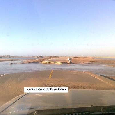
Wahoo, I do agree with terry C, although the picture you downloaded says Playa Encanto, it should say "Encanto Condos" which are located next to "Luna Blanca" condos, which I think is La Jolla Beach/Playa Dorada, about a couple of miles west of Mayan Palace, I am familiar with that area as I had to find my way into Mayan thru 2 monsoon seasons, and yes the entrance to "Encanto condos" could get 2 feet under water right at the turn where the road and the big dune before the shore is, nasty!!!
If you use Google Earth is does not always place things in the correct place. Why, I think you can upload pictures even if you don't know where you are I guess.
For info to others, Marua is the first and then Pinta is the second estuary going east on the Caborca hwy.
Richard Sabino; posts on FB; The water that's be running through the Sonoyta river for a week has now caused a problem on the eastern beaches of Rocky Point. The desert is flooded and the beach roads to the Mayan Palaca and Playa Dorada are flooded.
Recommend no travel today to the Mayan Palace or at least call the front desk for information. They are trying to repair and re route the entry road.
As I said earlier, the water is running to where it has ran for generations, toward the two estuary's with the most water running toward La Pinta. The water also used to run into what is now safe harbor too and early pictures confirm this.
We had several people come in today. All said that there was no delay and everyone was getting through. The last people that I spoke with came through around 2:30 this afternoon. The almost universal warning was "just watch out for the huge potholes".
A Tucson friend returned to Tucson from Santo Tomas (60 miles South of Penasco) via Nogales in 5 hours with no border wait (wow),so if you are headed to the Mayan (don't buy that timeshare) it might be your route of choice.
She is a safe driver so figure the 5 from Tucson is pretty solid to the coastal Highway exit at the Ejido by Santo Tomas (Alvaro Obrego which now has a really good restaurant owned by a great couple) add 2 hours to Tucson and an hour from Santo Tomas and figure 8 hours or so total time..Not good but better than waiting at Sonoyta.
I just returned from Santo Tomas, and had no problems crossing Thursday around four pm. The water was running pretty good and there were plenty of bumps and potholes so go slow!. It only took us five minutes to cross. Our friends came Friday at 10 am and found an hour delay and much chaos at the crossing. Several vehicles were being winched out down stream. They both made it across (a suburban and a 4 runner like mine). We heard it was closed after they crossed. We also crossed the rio again down by the airport on our way to Santo Tomas. It was still flowing pretty good there yesterday, but cars were going through. Some crazy guy driving a Yaris went through the Sonoyta crossing on Thursday!
Monday it was about a ten minute line up, but not much water going over compared to before. Safe Travels!
I just returned from Santo Tomas, and had no problems crossing Thursday around four pm. The water was running pretty good and there were plenty of bumps and potholes so go slow!. It only took us five minutes to cross. Our friends came Friday at 10 am and found an hour delay and much chaos at the crossing. Several vehicles were being winched out down stream. They both made it across (a suburban and a 4 runner like mine). We heard it was closed after they crossed. We also crossed the rio again down by the airport on our way to Santo Tomas. It was still flowing pretty good there yesterday, but cars were going through. Some crazy guy driving a Yaris went through the Sonoyta crossing on Thursday!
Monday it was about a ten minute line up, but not much water going over compared to before. Safe Travels!
There was a video on FB this weekend of someone in a small vehicle (maybe that Yaris???) trying to cross with a semi going in the opposite direction at the same time. Almost swamped the car....just about top of hood height with the water. Looked like he stalled out, but was able to start up again and limp through.
Ha! I did not see that one. This guy followed a full size pickup (full of kids in the back waving and hooting) through and did not stall by some miracle. The water was splashing up over his hood and way onto the windshield, but not over the roof. It never got more than a few drops on my windows in the 4 runner 4x4. We called it the Sonoyta self service car wash.
There are two reports on the Sonoyta Detour Updates that as per our friend Roberto, the reporter, said last week,
the new bridge, two lanes, will open tomorrow, Wednesday the 19th. This will be for cars and family "vehicles",
but not trucks.
I will report in tomorrow as I should be hitting there around 11:00 to 11:30 depending upon how much we eat at
Todd's at Ryan Field on the way. Happy trails....
Hit the wash at about 4:30 Monday afternoon. Road was DRY!!! Water still running heavy under the road. Crews were patching potholes. One thing to note is that the middle portion of the "bridge" is concrete and did not appear to have any damage so potholes are on either end of the bridge were where the water is a bit shallower. By the way, took the trip down from Phoenix on Saturday via San Luis/Coastal Highway. Very nice road. Took about 2 hours (and 140 miles longer) than normal but would do it again if I had too. Trip back that way will take longer due to inspections/border. As long as no rain in Southern Arizona/Northern Sonora, you'll be fine.
Wed. Sept 19, 2 PM. People just arrived coming through Sonoita, and reported water flowing UNDER through the culverts but NONE passing over the pavement.
Wed. Sept 19, 2 PM. People just arrived coming through Sonoita, and reported water flowing UNDER through the culverts but NONE passing over the pavement.
Doesn't matter. Reports say NEW BRIDGE IS OPEN.....ALL VEHICLES ARE PASSING! Cars, trucks, semi's. Both directions. truly great news!
Yes that is the mayan, but i was also talking about the new bridge in sonoyta too, are you sure they are letting all traffic thru?
Yes, I'm sure. I crossed at about 11:00 this AM and everything was going over the new bridge. One lane each way. No wait, no fuss...No detour signs.
The bad news is that from Ryan Field to the eddge of RP I passed only two cars and one semi. That means no one is headed this way right now.
Went to Mexico Beach Bum for a beer and the Old Port had quite a few people there. We were the only ones in the bar, but there was a great breeze up there.
Yes, I'm sure. I crossed at about 11:00 this AM and everything was going over the new bridge. One lane each way. No wait, no fuss...No detour signs.
The bad news is that from Ryan Field to the eddge of RP I passed only two cars and one semi. That means no one is headed this way right now.
Went to Mexico Beach Bum for a beer and the Old Port had quite a few people there. We were the only ones in the bar, but there was a great breeze up there.
I was awaiting your report...glad you made it and happy to hear about the new bridge! When news of its opening gets around I sure they will all be headin down! 13 days and counting for us.
Hope they didn't cut corners on the "new bridge" just to get it done quicker due to pressure. When we built our house down in PP - it was fairly quick (no inspection process to speak of so no waiting on permits, etc. - it's a little blind faith in doing stuff).
I didn't like the rebar layout in the bridge...seemed sparse...
Senor Pescado said:
Hope they didn't cut corners on the "new bridge" just to get it done quicker due to pressure. When we built our house down in PP - it was fairly quick (no inspection process to speak of so no waiting on permits, etc. - it's a little blind faith in doing stuff).


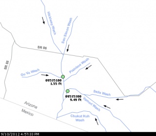 Good call Roberto...It is called the San Simon Watershed. I hope it works out where you can see it.