Things getting back to normal

Roberto

Well Known Member
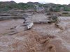
Most stuff will be back to normal by the weekend. Sun is out with a nice breeze and relatively low humidity. Pumper working on Calle 13. Grader out in Las Conchas already. Pools of water dropping of Fremont and Benito Juarez.
I bet things are still bad in the colonias though. They get service last if at all.
I think the storm broke the humidity . Oct 1 is usually a good target date to see the weather being more pleasant.
 

JayT

Active Member
Drove back to Phoenix from Las Conchas this morning and made it easily in my 4WD truck. Other than mud in Las Conchas and a few flooded roads in Rocky Point and just north of Rocky Point, the trip was fine. The 3-way intersection coming into RP at Benito Juarez and Dominguez is still pretty flooded and cars were wading through slowly. Heading north out of RP toward the bridge that intersects Hwy 8 and Hwy 3, there is a very flooded area that is difficult to pass in a car or low clearance vehicle, but easily done in a truck or SUV. Sonoyta was fine without any major flooding on the main road. Road north of the border toward Why and Ajo were fine too - just dried mud in the lower wash areas of the road. Safe travels everyone.
 

Mexico Joe

Cholla Bay 4 Life
Drove back to Phoenix from Las Conchas this morning and made it easily in my 4WD truck. Other than mud in Las Conchas and a few flooded roads in Rocky Point and just north of Rocky Point, the trip was fine. The 3-way intersection coming into RP at Benito Juarez and Dominguez is still pretty flooded and cars were wading through slowly. Heading north out of RP toward the bridge that intersects Hwy 8 and Hwy 3, there is a very flooded area that is difficult to pass in a car or low clearance vehicle, but easily done in a truck or SUV. Sonoyta was fine without any major flooding on the main road. Road north of the border toward Why and Ajo were fine too - just dried mud in the lower wash areas of the road. Safe travels everyone.
Thanks for the post, heading down tonight in the dark! LOL
 

Terry C

Well Known Member
Sonoyta by-pass road, That's not Graffiti on the rock, it's picture signature.... LOL

picture won't post, the road is washed away
 

Roberto

Well Known Member
They just cannot get the hydrology engineering good for this. If you study the Google map area in Arizona just across the border along the Rio Sonoita in Mexico, you see it is a slope that drains a huge area in Arizona into the Rio Sonoita in Mexico. You can follow the drainage from the map. A huge amount of water passes from the US into Mexico, illegally without papers, causing massive flooding in Mexico. Need to build a wall and flood Lukeville !!!

I never used the bypass cause I like the drive through the colorful downtown area. By passes in the US have ruined lots of commercial enterprises in town and cities.
 

Southbeacher

Well Known Member
Caborca Road still only open to emergency service vehicles as of 1:00 AM Thursday. No other traffic allowed. Sonoita River flooding at kilometer 17, where the water is 2-3 feet deep.
 

Terry C

Well Known Member
We have a river!

Remember the river we would have on the road between the Caborca Hwy and the guard gate after huge rain storms in the mountains.

Well she is running again....bottom line, if you are in Playa Encanto you are blocked from getting to the Caborca Hwy. It’s impossible for Rhonda to get into town for water, so conserve.

If you are planning on going to the beach please wait until the road is re-opened.
 

JimMcG

Well Known Member
Caborca Road still only open to emergency service vehicles as of 1:00 AM Thursday. No other traffic allowed. Sonoita River flooding at kilometer 17, where the water is 2-3 feet deep.
Is the Mayan/Miramar/Dorado road open and passable from kilometer post 22 on the Caborca Hwy?
 

Southbeacher

Well Known Member
Is the Mayan/Miramar/Dorado road open and passable from kilometer post 22 on the Caborca Hwy?
No! While it was passable late Wednesday night (October 3) via 4-wheel drive, as of today (October 4), the continued dumping of the Sonoita River over the Caborca Road (at kilometer 17, which is still not passable) and into the estuary, caused new flooding onto the Mayan / Miramar / Dorada Estuary Road. That road is now totally submerged.
 
Last edited:

JimMcG

Well Known Member
Yes, The estuary road from the Caborca Road to Dorada, at least. Not sure about Dorada to Miramar / Mayan on that same estuary road, but Dorada to Miramar / Mayan on the Caborca Road is open. The only unknown is the Caborca road before those points (kilometer 17), which was not passable as of early AM October 4.
Thanks
 

JimMcG

Well Known Member
See my edit based on recent update!
Yes, this was my concern after hearing of the Playa Encanto road being blocked for the same reason. It happened exactly the same way after a previous heavy storm also.
Thanks for the update though.

I wonder if the Mayan would allow ingress and egress to Miramar/Dorado through their gate if in fact it is passable.
 
Last edited:

Southbeacher

Well Known Member
Yes, this was my concern after hearing of the Playa Encanto road being blocked for the same reason. It happened exactly the same way after a previous heavy storm also.
Thanks for the update though.

I wonder if the Mayan would allow ingress and egress to Miramar/Dorado through their gate if in fact it is passable.
Thing is, how would you get to Mayan? While we've traversed the Caborca-Road flooded washes from time to time, this flood -- at Kilometer 17 -- is 2-3 feet deep . . . extends for at least 200-300 yards . . . . is blocked by officials to all but emergency-service (fire-truck-sized) vehicles . . . and is still flowing.
 

JimMcG

Well Known Member
Thing is, how would you get to Mayan? While we've traversed the Caborca-Road flooded washes from time to time, this flood -- at Kilometer 17 -- is 2-3 feet deep . . . extends for at least 200-300 yards . . . . is blocked by officials to all but emergency-service (fire-truck-sized) vehicles . . . and is still flowing.
Right, 2-3’ of water is one thing while the other is whether all of the 200-300 yards of road is still there under the muddy water. No choice but to hunker down for now
 

JimMcG

Well Known Member
I was just told by a local contractor that he drove down the Caborca road and tried the Mayan Palace road today but that the road between Luna Blanca and Playa Dorado was like a lake and impassable.
 
Last edited:

MIRAMAR

Well Known Member
Road to Caborca where the Sonoyta river empties into LA Pinta estuary is flooded to about 2 feet high for quite a distance, (before Miramar) There were police warning last night but still a shock. Not sure a regular car could get through it, but trucks and SUVS are fine. We took the Mayan palace road to Miramar which is mostly paved, but there is a patch of water and mud so be careful
 
Top