Hurricane a comin .

mondone

Whitecaps
I talked to people this morning who saw what was posted , drove from Encanto to Luna Blanca on the beach and took the Mayan road out. Not sure if they went to caborca then sonoyta or penasco then sonoyta[/QUOT

I was told that is not being condoned by the officials for anyone to do on their own.. The Marines were not able to get into Encanto this morning on our road to evacuate another group looking to get out and had to turn back. They are going to attempt coming in later today when the high tide recedes along the beach from the Mayan instead and they have OK'd anyone in Encanto with a 4 wheel drive vehicle to follow them back along the beach to the Mayan road.
 

Southbeacher

Well Known Member
Does anyone happen to know about the Caborca-to-Sonoyta route . . . . if it is a relatively easy trip, with decent road conditions?
 

danwerle

Member
The Caborca to myan route is perfect no issues the only problem is the river crossing between Myan and Penasco, we came that way during the race on sat
 

Roberto

Well Known Member
10/8/2018 8:00:00 AM

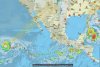
Hurricane Sergio continues to drift to the northwest over the open waters of east Pacific today, well away from any landmasses. Later tonight and Tuesday, Sergio will begin to move northeast toward the Baja Peninsula, where it could make landfall sometime later this week, probably as a tropical storm or tropical depression. Moisture from Sergio should then expand over northwestern Mexico and accelerate northward into the southwestern United States by Friday, leading to the potential for heavy rainfall.
By AccuWeather Senior Meteorologist Paul Walker
 

brokenwave

Well Known Member
Roberto, I like my version better, less chance of RP flooding out again.
Should know better by late Tuesday if the hatches need to battened down.

Hopefully my version is correct, but then further south will then suffer. Not good for anyone.
 

Roberto

Well Known Member
Well I certainly hope it does not cross near here. We have had enough of that for a few years !!
 

audsley

Well Known Member
Watch the weather. Too early to tell.

But I'll add that Thursday we took the highway toward Mayan Palace and were among the first they let through. Rio Sonoyta was running deep across the road in several place and a railroad bridge had collapsed. Sunday we returned from Puerto Lobos expecting to find only mud on the road, but instead the water was still running and we had to go very slow in a 4WD truck. Passenger cars were making it but barely. We believe they had diverted water from beneath the train bridge so they could repair the bridge, resulting in runoff being concentrated in just a couple of crossings. When we passed over Rio Sonoyta again about halfway to Sonoita (that bridge over a usually dry wash) it was still running fast. The river's headwaters are in the US and it collects over a wide area. And the ground is really saturated now.

The message here is that there are more variables at work than just the rain forecast.

If your friends are really determined to reach Mayan Palace, you might inquire about turning off Highway 8 roughly 40 kilometers past Sonoyta. My map shows this road going past the Sierra Pinta mine and leading right to the Mayan Palace. It completely avoids the flood area. But since I've never taken this road myself, I advise getting confirmation from someone who knows for sure that this road does what my map says it does. And someone would need to tell you where to turn off of Highway 8. It looks to be about 40 kilometers past Sonoyta.
 

Landshark

Well Known Member
If your friends are really determined to reach Mayan Palace, you might inquire about turning off Highway 8 roughly 40 kilometers past Sonoyta. My map shows this road going past the Sierra Pinta mine and leading right to the Mayan Palace. It completely avoids the flood area. But since I've never taken this road myself, I advise getting confirmation from someone who knows for sure that this road does what my map says it does. And someone would need to tell you where to turn off of Highway 8. It looks to be about 40 kilometers past Sonoyta.
I think that road has been discussed on here. If it’s the one I’m thinking of I remember it being more of a Jeep trail.
 

Stuart

Aye carumba!!!
Staff member
They THINK Sergio will go further south at this point, but... it's a hurricane. They go where they want to go and it's still like 1200 miles out and only moving at 3 mph.

Guess we'll see.
 

brokenwave

Well Known Member
As Sturart said, Tuesdays map is showing Sergios track has shifted approx 50 miles further south vs Mondays.
 
Top