Hurricane a comin .
- Thread starter Roberto
- Start date
Roberto
Guest
The "Road' is at best a Jeep trail and not to be tried solo. That's Gillespies old road he built to get to the mine and his hacienda on the Estro La Pinta, Read about it in Gilliespies Gold, the book.Watch the weather. If your friends are really determined to reach Mayan Palace, you might inquire about turning off Highway 8 roughly 40 kilometers past Sonoyta. My map shows this road going past the Sierra Pinta mine and leading right to the Mayan Palace. It completely avoids the flood area. But since I've never taken this road myself, I advise getting confirmation from someone who knows for sure that this road does what my map says it does. And someone would need to tell you where to turn off of Highway 8. It looks to be about 40 kilometers past Sonoyta.
I have not been there for a few years. The military closed off the road to the mine. Told me they had a shooting range across the road !! I passed a 4WD club of about 10 vehicles coming out about 10 years ago. I was at the mine when they came through looking all battered with a determined look on their faces!!
I'd love to try again. Who wants to go ?? Need 4WD.
Roberto
Guest
Hey great Map. Where did you get it?? Not real accurate but I LOVE maps. But as posted, it's not really a road.Here's what I was talking about. Head out of Sonoyta like you normally do and take the road that leads past Villegran. But only after someone who knows this road confirms that it goes thru as shown and is in decent shape.
View attachment 16485
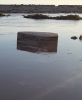
It's one of the exposed electric junction boxes. See the man hole cover? The cover used to be at ground levelGeez, Terry! That's looks like a coffin that washed out of somewhere!!! Oh my...
Landshark
Guest
Joe’s grave is right about there. I think Stuart is right!!It's one of the exposed electric junction boxes. See the man hole cover? The cover used to be at ground level

Roberto
Guest
It's a GREAT IDEA properly equipped and prepared.Okay, I just Google Earthed the road on my map. That road is definitely not a good idea.
Roberto
Guest
I have, somewhere in the computer files, a government produced map that states it show ALL the roads in Sonora. I'll try to find it again. Wish there were Geodetic Survey like maps available. I have them of every scale of the Gila in New Mexico !Roberto, it's a Mexican map with no date of publication but obviously before 2010 as it doesn't show the highway going all the way to Libertad. I'd like to have an updated version.
mondone
Whitecaps
Yep, watch out Guaymas. Still predicting rain and gusty winds here Friday though.As Sturart said, Tuesdays map is showing Sergios track has shifted approx 50 miles further south vs Mondays.